
Google Maps has an answer for everything.
In twenty years of riding with it, I’ve seen “No routes available” exactly once, and that’s because I went looking for it, plotting something ridiculous across Alaska just to poke at the algorithm. It always finds a way. It might be a bad way. It might run through a Walmart parking lot and down a dirt road. But it always has an answer.
I didn’t expect “No routes available” to show up in North Carolina.
The day didn’t start with much of an answer either. Boone was 36 degrees and raining when I woke up. Breakfast was a 35-minute wait for a table. I gave up and ordered takeout, and the takeout took 35 minutes too. The cashier got the order wrong for the person before me, then got my order wrong. I wasn’t going anywhere before noon, and honestly, I didn’t want to.
While I was packing the bike, a couple in their 60s asked me who my college team was playing today.
I didn’t know.
The husband gave me a look of pure disgust and walked off. I just didn’t know. I’ve been out of the proverbial loop since I left Savannah weeks ago. I’ve not needed the news, as my own world is the five moving miles around me.
It was such a small thing, but it stuck with me all day. I’m not used to feeling like an outsider down here. I’m from here. I get the culture. I can put on khaki-colored pants and pretend I went to church, drink sweet tea, and talk about the weather with anybody. In five seconds in a hotel parking lot, I was the guy from California. One question, and he’d decided he knew what I was.

The rain stopped around noon, and I hopped on my bike and started up the Blue Ridge Parkway.


The first thing I saw was classic cars, at least a hundred of them, chrome and two-tone paint rolling down the Parkway like it was 1957. Being in this moment, seeing the old cars on an American transportation legend, was surreal.
The farther I got down the Parkway, the more the sky started to open up, and the color came out.

I’ve been chasing fall color since hopping on NY-97, nearly two weeks ago. Skyline Drive had its moments. The Virginia end of this same Parkway was good. But most of the trip, I’ve been a week early or a week late, catching it in patches. Somewhere along the way I’d started to wonder whether I’d ridden this far for nothing.


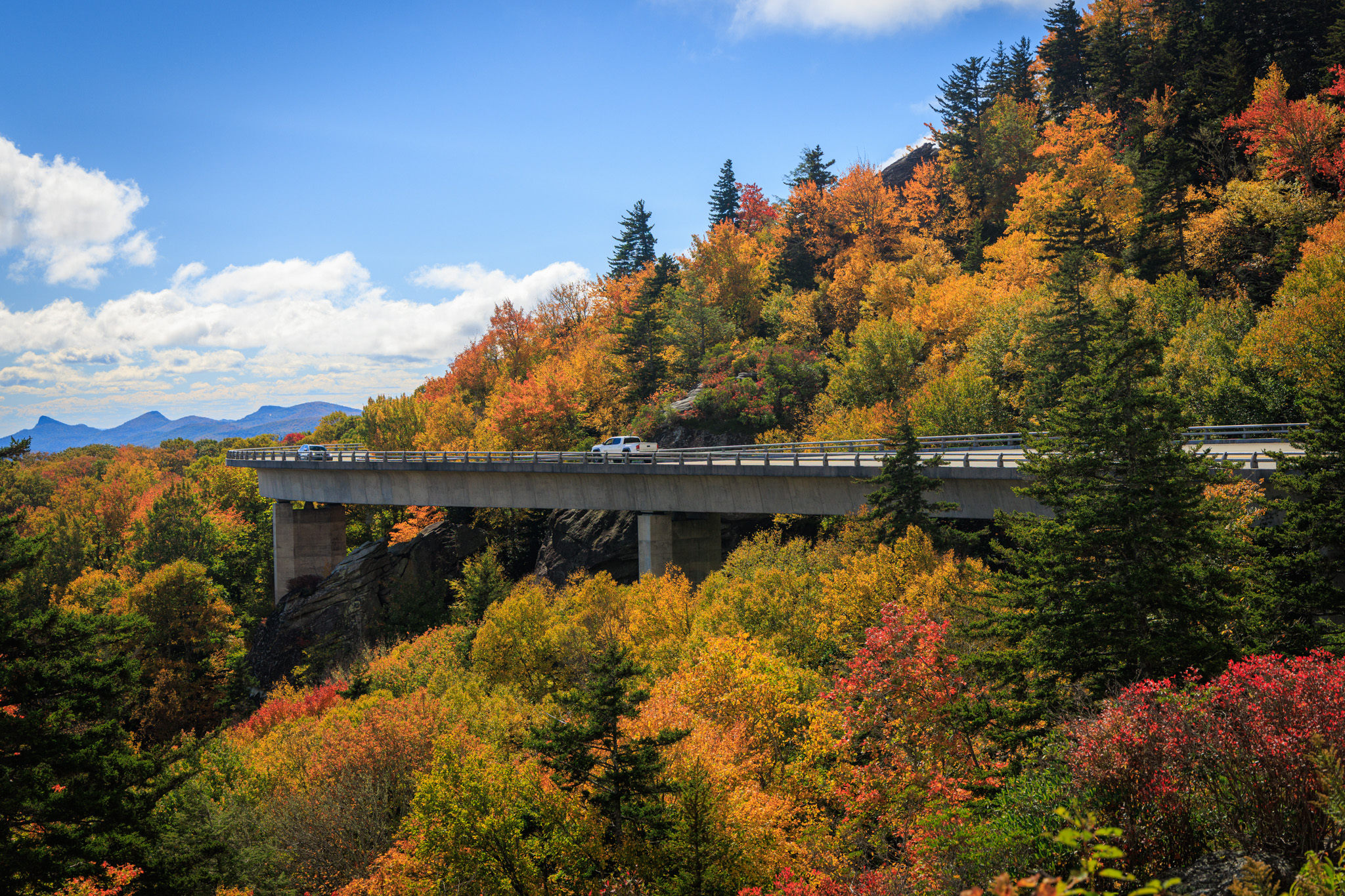
Not today. Sims Pond was black and still, with the whole hillside burning in the reflection: reds, oranges, yellows, and the dark green of the rhododendron underneath holding it together.


Grandfather Mountain kept pulling clouds over its summit and then throwing them off again. The Linn Cove Viaduct wraps around the mountain’s side through all of it, 1,243 feet of road built in 1983 so they wouldn’t have to blast through Grandfather to finish the Parkway.


I felt vindicated. All those miles, and the color finally showed up!
Fall is the one season that ends by letting go, and makes letting go look beautiful. I’m just over six months into not working, closer to the end of this chapter than the beginning, and I could get my head around ending like this.


However, everyone else in the Southeast had the same idea. Saturday traffic around Grandfather was as bad as anything I sit in back home in the Bay Area.

At an overlook I met Ben. He moved here from San Diego, absolutely loves it, and hasn’t looked back at California at all. He told me he’d ridden all the way up to a town that started with M, near the Oregon border.
“Mendocino?” I offered.
He smiled. “Yes.”
Mendocino is about 250 miles and five hours from Oregon. There’s an entire Northern California up there he never saw. I didn’t say it.


I’ve asked myself whether I could make the move Ben made. What he gave me wasn’t an answer, but it was clarity. His California and mine aren’t the same place. Southern California isn’t the motorcycling paradise Northern California is, and from San Diego, I can absolutely see the lure of these mountains. From San Francisco, it’s a harder sell. Both things can be true. I just need to remember which California I’m comparing.


Again, I forgot about lunch. By the time I remembered, I was starving, and the Parkway doesn’t do lunch. I got lost looking for some and ended up stuck on 226A, which turned out to be a squiggle of a road and a lot of fun. It dropped me into Little Switzerland, where two guys on light dual-sports told me I should have added a gravel section.


I smiled and told them 226A was enough.
Their suggestion and my reality almost lined up. I just didn’t have the gravel.
I’d already mailed my dad a North Carolina postcard from Elon University on the way north. It hadn’t felt complete. Elon was a stop. This was North Carolina. So somewhere on the Parkway, I sent a second one.


After lunch, Google gave me the answer I’d never seen.
No routes available.
That morning it had me on the Parkway all the way to NC 80 and then down into Asheville. Now every recalculation turned me around, and every turnaround ended the same way. No routes available. When Google Maps runs out of answers, you have to ask yourself how effed up you are.
I pulled over and checked the Parkway’s website. Two years after Helene, the Parkway still isn’t whole. The section in front of me wasn’t open. It wasn’t closed. It was “ungated,” whatever that means. If NC 80 was really cut off, I’d have expected a ranger or a sign at the last big crossing saying so. There was nothing. Meanwhile, cars kept coming north toward me. Either the road was open, or they were all people who’d already found out it wasn’t.

The low that night was going to be in the high 20s. If I was wrong, I’d be backtracking in the cold and the dark, paying for one bad decision with every mile. The Parkway can be harsh like that. You can’t easily get back to civilization when things go bad.
Two years ago, I’d have pushed through anyway, but only because I’d have had no choice. I had a schedule that ended Sunday night, and Mondays demanded I be back at work. Now, nobody’s waiting on me. Turning around would have cost me nothing but a few hours. That’s what made going forward a real decision.
Screw it. This is what adventure is.
What I felt was a little relief, a little caution, and a little fear. All three rode with me down the next 20 miles.


Turns out, Google had the wrong flyover marked closed. NC 80 wasn’t just open. It was one of the most beautiful pieces of pavement on this whole trip, squiggling down through the Appalachians in tight 20 mph switchbacks, clean and nearly empty after a day of brake lights.


I have family in Asheville. They were Californians too. Some came for work, and some came for family. They stayed for the culture, the weather, and being close to one another. Every one of them seems a little surprised by how much they like it here. They all found their answer.
I don’t have mine yet. For now, it’s ungated.
Ride Details
Route Map
Start
Boone, NC
Destination
Black Mountain, NC
Distance
Approx. 100 miles
The Ride at a Glance
Scenery
★★★★★
Curves
★★★★☆
Road Surface
★★★★★
Traffic
★★★☆☆
Difficulty
★★★☆☆



Leave a Reply