Background
A few weeks ago I got a special package in the mail from my niece. I had been selected for a Flat Stanley project. Flat Stanley is a children’s tale where Stanley gets a new bulletin board for his room. One night as Stanley is asleep the bulletin board falls on top of him (he must have been in California for an earthquake). Because the bulletin board fell on top of him, Stanley is now paper thin. Stanley then gets mailed to someone far from home to learn about places throughout the world. Since California is a long way from home I got selected to receive Flat Stanley.
I had not heard about Flat Stanley before. Once I read up on it I was excited about the project. As a kid, I always loved the Dr. Seuss book “Oh, The Places You’ll Go!” I wasn’t exactly sure where we’d go but I knew it would involve a motorcycle, some gas, and Labor Day weekend. Because California is so big it was hard to think through what I wanted to show about this crazy place. I did however want to ensure that it was all done together. I didn’t want to pull artwork from several years ago to fill in stuff that I couldn’t get to. Flat Stanley had to see it all!


Day One: San Jose to Fort Bragg
We started off in San Jose. California is well known for its contribution to the technology industry worldwide. Apple Computer, Netflix, Google, and others are key players in the market in this area. Since I work there, Atlassian made that short list as well. 🙂 We even have the JIRA Junior version specifically designed for kids.


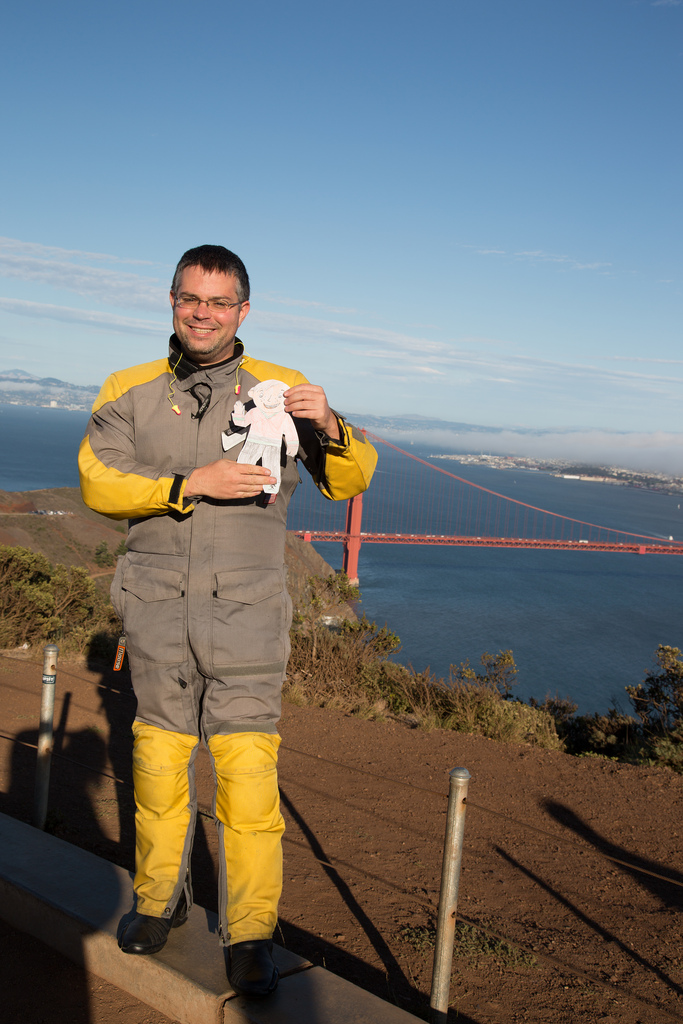
I actually hit the Golden Gate Bridge at just the right time. The fog was rolling in which afforded some great pictures to demonstrate what fog was. The east side of the bay was still clear so that Alcatraz Island as well as Oakland was visible. I met a couple on vacation from Minneapolis who were visiting family in Sacramento at the bridge overlook. Megan knew exactly who Flat Stanley was and instantly jumped up to take a photo. She had done three Flat Stanleys before so it was great to get some tips from a “professional.”


I got a late start to the day (no surprise there) so it was very much a direct ride up to Fort Bragg. The Bay Bridge was closed so traffic to San Rafael was the worst I had ever seen it. I always forget how far destinations in the north bay really are as I don’t travel that area all that much. Highway 20 runs from Willits over to Fort Bragg. It’s a fairly technical ride during the daytime so with darkness and fog it was a slow crawl out to the coast from highway 101. It was great meeting Johnny and Brad as they were excellent hosts for the evening. 30 minutes in the hot tub as well as a comfortable bed did this body good.
Day Two: Fort Bragg to Mount Shasta
The next morning we got breakfast at David’s which is a local diner in town. Both Johnny and Brad are very connected in the community here so it was fun to see the area through more the eyes of a local than a tourist. Fort Bragg and the coast had a nice layer of fog for some summertime fun!


I left Fort Bragg just after noon and headed up to Leggett to the Chandelier Tree. As many times as I go up to the north coast I’ve never stopped here. It’s clearly a tourist trap but something that I think a third-grader would really find interesting. The place was mobbed but actually worth the visit. The Chandelier Tree is big enough you can actually drive through it. Because the tree is so big it looks somewhat like the Giant Sequoias. The line was too long to actually drive through the tree so I settled for a quick picture.


![[Group 1]-Flat_Stanley_Labor_day-85_Flat_Stanley_Labor_day-91-7 images](https://i0.wp.com/dashedyellowline.com/wp-content/uploads/2013/10/group-1-flat_stanley_labor_day-85_flat_stanley_labor_day-91-7-images.jpg?ssl=1)
![[Group 1]-Flat_Stanley_Labor_day-106_Flat_Stanley_Labor_day-108-3 images](https://i0.wp.com/dashedyellowline.com/wp-content/uploads/2013/10/group-1-flat_stanley_labor_day-106_flat_stanley_labor_day-108-3-images.jpg?ssl=1)
Eureka! I found it!

At this point it was about 4 o’clock in the afternoon so crossing highway 36 and getting to Mount Shasta was looking slim. I’m beginning to refer to highway 299 as “old man’s 36.” Highway 299 is more gentle and can be a faster ride if traffic is on your side. Boy was I in luck! I think in the whole 150 miles from US 101 to Interstate 5 I only had to pass 3 cars. Talk about luck!


I hit Whiskeytown Lake at sunset and made it into Redding about 8:45 PM.

I stopped in to Safeway to get some dinner and breakfast the next morning as I knew things were closing up. The stretch from Redding to Mount Shasta was probably the most difficult ride I’ve done in a while. Cool air was coming down from the mountain, there was lots of truck traffic in the area, and it was a long day. The good thing is that there wasn’t much side traffic on the interstate so was easy to make miles. I was planning to camp but decided to stay in a hotel as it was late and I didn’t want to set up a tent. I checked into a hotel and realized the room failed the bedbug check. When I went back to the front desk I saw the staff leaving and caught them in time. I got a new room and that room failed the bedbug check as well. At that point the staff had left, so I left the room and found a campsite as most of the other hotels were either booked or closed. I got to the campsite at midnight and had to set up a tent I had never set up before in the dark. Sometimes motorcycling and vacation is hard. This was one of those nights.
Day Three: Mount Shasta to Pioneer
I slept really well. Today was going to be a fun day through the volcanic area of California. Mount Shasta is a volcano at over 14,000 feet in height. It sits out on the open plain so the magnitude of the volcano can be clearly felt. I spent some time in the town of McCloud. Larry spent some time talking about McCloud’s history as a railroading town. I had hoped to camp at Lower McCloud Falls but the late-night arrival last night forced me to stay at a KOA. It was fun playing with a polarizer to bring out the sky and the red barn in this photo.

Lassen Volcanic National Park was next on the list. No other area has the diversity of volcanic features such as the devastated area, the volcano, and boiling mud pots like Lassen.


![[Group 3]-Flat_Stanley_Labor_day-186_Flat_Stanley_Labor_day-195-10 images](https://i0.wp.com/dashedyellowline.com/wp-content/uploads/2013/10/group-3-flat_stanley_labor_day-186_flat_stanley_labor_day-195-10-images.jpg?resize=1024%2C430&ssl=1)
There was a little bit of line heading into the park. I met Kent sitting in line. We’re basically doing the same thing for Labor Day weekend: wandering around to random destinations on motorcycles.

Leaving the park I had 2 options: get rained on in the High Sierras or endure high temperatures throughout the Central Valley. I felt like going to the Central Valley was lesser of two evils. Stanley did enjoy seeing where all the food in the states gets grown! 🙂


The ironic thing is once I got to Sacramento I got rained on anyway. Joey had just bought a house up in Pioneer so I wanted to go see him and his new place in the hills. Once the weather dried-up it was a great ride into the gold country. Summer rain showers are so ironic here in California it was fun to photograph the weather going across the central Valley as soon as I was out of it. The long gray streaks from the clouds against the sunset were quite cool.


With this new camera I need to learn how to take sunset photos again. I was able to capture one I was happy with using high dynamic range photography but I’m curious to see if I could do it with the standard exposure at some other time.
Nearby, the Rim Fire has burned a large portion of land so the air quality was clearly diminished. I could smell the smoke through my helmet. I’m wondering if the smoke enhanced some of the colors that were seen as the sun was setting.
Day Four: Back to San Francisco
The last day was all about rolling over the new Bay Bridge. They say the bridge is 6 years late and $5 billion over budget so I was curious to ride across it on opening day. I was feeling the get-home-itis as this was my fourth day on the road. The new bridge I’m pleased to report is really cool. It was great riding into Treasure Island and taking the parting photograph with Stanley.


I have to say I really enjoyed the project. As a kid, the Dr. Seuss Book Oh the Places You’ll Go was one of my favorite books. Some thirty years later I now know why. The open road always calls either on foot, two wheels, four wheels, or by airplane.
Lisa, wherever you go in life; never stop exploring.
Route:
Leave a Reply